📌 Geotag Photo
Add geolocation data to images to boost local SEO signals and improve local search performance.
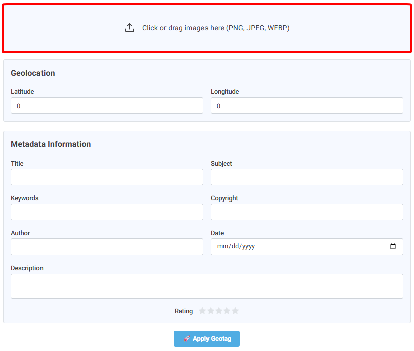
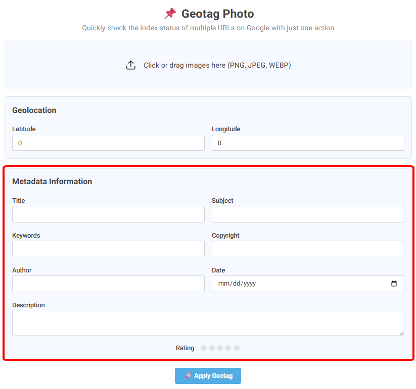
Click or drag images here (PNG, JPEG, WEBP)
Geotagging photos is one of the small and effective SEO tricks to optimize image search and manage content effectively. With the Geotag Photo Tool by ScapBot, you can add GPS location and metadata, such as title, Keywords, Author, Date, and Description, to multiple images at scale. While this process is entirely online and free of charge, it helps Google to understand content and the geolocation of the photos, then enhances their visibility on the SERP, especially in local search. Besides, Geotagging helps to improve brand identity and bring in several advantages for SEO.
This tool is handy for local businesses, e-commerce sites, travel/food blogs, real estate websites, and any content where images are tied to specific locations and need accurate data for search engines to understand.
What is image geotagging, and why does it matter for SEO?
Geotagging means embedding location information (latitude/longitude) and metadata (EXIF/IPTC/XMP) into your image files. When your images contain full context — such as where, what, who, and when — search engines and content management systems can better understand the subject, location, and ownership of the image.
What makes Likepion Geotag Photo stand out?
Photo Geotagging Tool by Scapbot has several unique selling points that help it stand out from other competitors in the market.
- Batch processing: Instead of tagging one image at a time, you can geotag multiple images at once — a huge time saver for content or SEO teams.
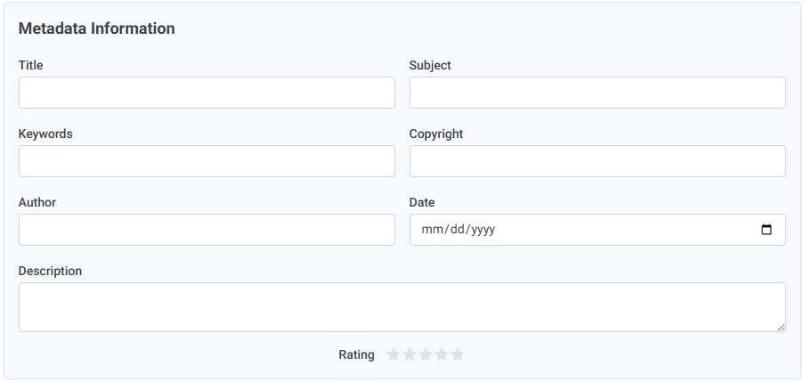
- More metadata fields: In addition to GPS (lat/long), Geotag Photo lets you add Title, Subject, Keywords, Author, Date, and Description — giving your images a full “profile” in Google Eye’s.
- User-friendly & simple visual: Just drag-and-drop images, enter your data, apply geotags — and done. No software installation, no cost.
- Image quality preserved: The tool processes images using standard-compliant methods, ensuring that your photos remain sharp and ready for publishing.
Most tools only allow geotagging a few images at a time with 2–3 basic metadata fields. Geotag Photo by ScapBot stands out with its batch processing and ability to add multiple metadata fields in one go (Title, Subject, Keywords, Author, Date, Description + GPS). This saves you time while giving your images complete metadata “profiles,” ready for SEO and long-term asset management.
How to Geo-Tag Photos with Scapbot?
-
Step 1 – Drag and Drop Images
Upload the images you want to geotag. You can upload multiple images at once from this step to save time.
-
Step 2 – Enter GPS & Metadata
Location: Paste the coordinates (latitude/longitude) or search on the map and take the data.
Recommended Metadata:
- Title: Short, includes the main keyword (e.g., “Hoi An Ancient Town Banh Mi”).
- Subject: Add context (e.g., “Central Vietnam Specialty – Hoi An”).
- Keywords: 3–6 naturally related phrases, without keyword stuffing.
- Author: Brand name/photographer’s name.
- Date: Date the photo was taken/released.
- Description: 1–2 sentences describing the photo content, location, or product.
-
Step 3 – Apply Geotag & Download
Click Apply Geotag, wait for the system to process, then download the image package with full location and metadata embedded.
Tips for Filling in GeoTag Placeholder for Better Optimization:
The tool is too simple. However, for better optimization, you should follow some recommendations:
- Prefer JPG format: PNG/WEBP is supported, but may have metadata stripped on some platforms.
- Use clear filenames without accents + include keywords, e.g.,
types-of-backlinks.jpg. A descriptive file name helps search engines better understand the image context. - Write natural ALT/Caption text aligned with page content. ALT should describe the image as if you're speaking to the user, including keywords moderately (e.g., “25 types of backlinks”).
- Check plugins/CDNs: Some image compression systems may strip EXIF (Exchangeable Image File Format). After uploading, re-download the image to ensure metadata is preserved.
- Combine with ImageObject schema: For key galleries (e.g., product or project pages), use ImageObject (with contentUrl, caption, author, datePublished, thumbnailUrl) to enhance semantic clarity for search engines.
- Align image with page context: H1/H2 titles, nearby text, internal links — they should all “tell the same story” as the image for consistent signals.
Does geotagging help rank better on Local/Google Business?
Geotagging gives images a clearer context. While some platforms remove metadata on upload, don’t treat geotagging as a “magic element” for Local SEO. However, for images hosted on your site, full metadata still supports SEO and content management.
Why is EXIF sometimes lost on social media?
Many platforms compress images to optimize speed and privacy, often removing EXIF data. This is not an issue with your image, but the platform.
What image format should I use?
JPG is recommended to retain stable EXIF data. If you use PNG/WEBP for quality or size reasons, test by uploading and checking whether your website/CDN preserves metadata.
Does geotagging increase file size or reduce quality?
Metadata only adds text-based info to the file — it doesn’t reduce image quality. File size may slightly increase, but it's usually negligible.
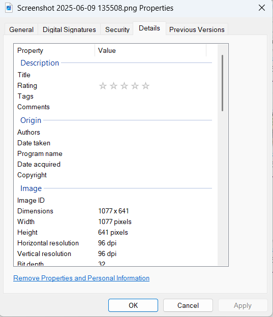
How to geotag photos manually?
To geotag photos manually, you just need to save your image, then click on Properties> Details, and then you find all the information to fill in.
Ready to optimize your image library?
If you want to put photos geotagging process to the next level, try Geotag Photo by Scapbot for free: Just Drag‑and‑drop → Enter GPS & metadata → Apply Geotag → Download. Need automation at scale (fast indexing, consistent SEO workflows)? Upgrade to LikePion to accelerate the entire content lifecycle.